New Method of Detecting Plastics in the Ocean from Satellites in Space Wins Award
Professor Chris Ruf and Madeline Evans won a 2022 Ocean Award for their work detecting microplastics in the ocean using CYGNSS.
Professor Chris Ruf and Madeline Evans won a 2022 Ocean Award for their work detecting microplastics in the ocean using CYGNSS.
U-M Climate and Space Professor Chris Ruf and Madeline Evans, who worked with him as an undergraduate research student, garnered the Science Award in the 2022 Ocean Awards during a live virtual broadcast on May 4, 2022. Sponsored by Boat International and the Blue Marine Foundation, the award recognizes significant contributions to science that support ocean health or global marine conservation.
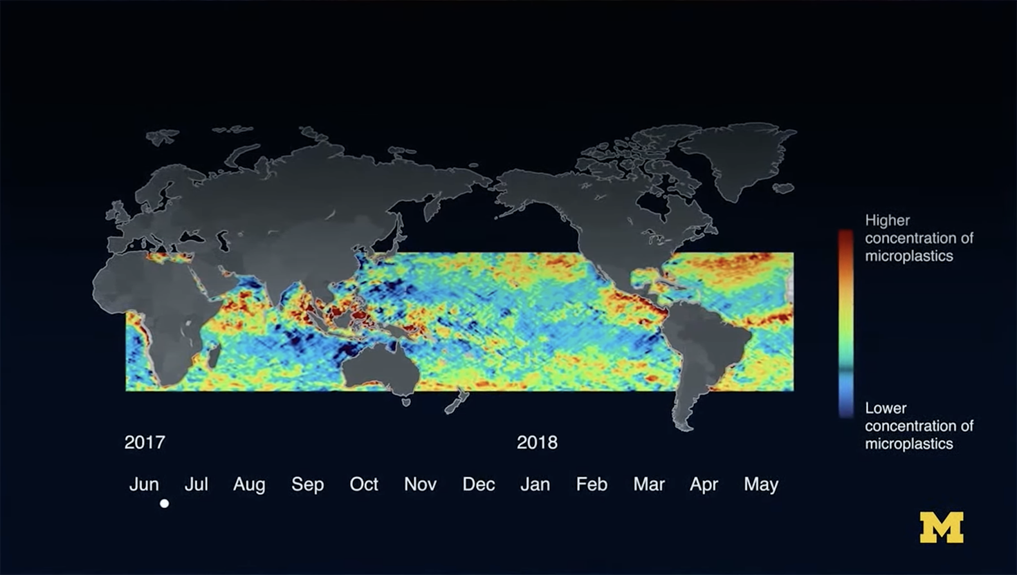
Ruf and Evans developed a new method for detecting and imaging ocean microplastic concentration using the NASA Cyclone Global Navigation Satellite System (CYGNSS), a constellation of spaceborne radars. They tapped the eight microsatellites to measure how wind roughens the surface of the ocean, which allowed them to pinpoint large concentrations of microplastics.
“Incredibly, this genius initiative uses satellite imagery of sea surface roughness to detect the density of microplastics anywhere in the world and all year round. It’s a live data feed of where the microplastics are and where they’re going. It’s amazing,” said Sacha Bonsor, of Boat International.
“The original idea for this detection technique really arose from a related technique that’s used with satellites to track oil spills,” said Ruf. “They do that by looking at how the presence of the oil suppresses the roughness of the ocean, so we just expanded on that idea.”
Before this method was introduced, microplastic data was often sourced from research boats towing large, meshed nets, which could only map small areas at a time. By studying data from CYGNSS, Ruf and Evans were able to detect the presence of microplastics in the ocean anywhere in the world.
“The wind over the water causes these little ripples and you can easily see them with radars and satellites,” said Ruf. “We looked at how windy it was using other satellite measurements and predicted from that how rough the surface should be, and then we made direct measurements of how rough it actually was with those satellites. The difference between those is caused by something suppressing the roughening of the ocean. We hypothesized that was that presence of microplastics, because that’s a similar type of physical mechanism as happens with oil spills.”
Not knowing whether the project would be successful, Ruf collaborated with Evans, who was an undergraduate student at the time. She spent a year learning about the microsatellites, the data they produced, and the correlation between the ocean’s surface and the build-up of pollutants.
“I really wanted to get involved in research in the Climate and Space department [and] do something with environmentalism, because as with many people that are college age and even younger, you feel like you really want to get something done,” said Evans. “You get all this bad news from everywhere, and it’s a little bit stressful, so you want to do something.”
As they dove into the research, Evans reviewed the data carefully. She ran a calculation that showed that there was a very high correlation between the suppression of surface roughness in the ocean and the presence of microplastics.
“I have a huge appreciation for the satellite system that we’re using, for which Chris is the principal investigator,” said Evans. “It’s a bistatic radar system, which is a pretty advanced way of measuring the entire roughness spectrum of the water.”
The research team was surprised they were able to use satellite data to detect large concentrations of microplastics in the ocean, while also tracking the movement of these pollutants. As the research team worked on the project, they also made a few discoveries along the way.
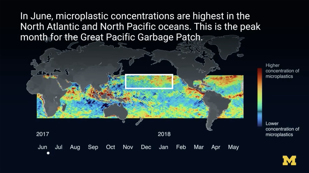
“Since we’ve matured the technique and started using it to do science, we’ve discovered a couple of new things,” said Ruf. “One of them is seasonal variations in the microplastic concentrations in the big ocean gyres, where the plastics tend to concentrate over time – that they are higher in the summer, lower in the winter, and they have a very consistent, periodic variation.”
More importantly, the research team was able to trace plastic pollutants in the ocean back to their source, especially as it relates to the major rivers that feed directly into the ocean.
“We’ve also been able to image outflow of the plastic from most of the major rivers on the Earth that we were able to measure with our satellites, and we can see these episodic bursts of microplastics leaving the mouth of the river out into the ocean,” said Ruf. “We can see those things happening. We knew they were happening, anecdotally. Being able to actually image them happening is a really powerful confirmation of that.”
Over the course of the project, Evans said one of the most striking moments for her was seeing the radar maps.
“It’s one thing to have a statistic that shows you, ‘Oh, this might be seeing microplastics in the ocean.’ It’s another thing to watch them go around the world and think of how this could have some sort of impact.”
The new method of detecting microplastics could change the game when it comes to cleaning up our oceans and marine conservation.
Ruf said the data will be useful to scientists and conservationists, because it gives people a way to measure the amount of plastic in the ocean, to observe how the concentrations change over time, and to image the sources of the microplastics, in order to provide solutions to the problem.
Prof. Chris Ruf is a member of the Task Force on Remote Sensing of Marine Litter and Debris (UNESCO/International Ocean-Colour Coordinating Committee) and the former Editor in Chief of the IEEE Transactions on Geoscience and Remote Sensing. Madeline Evans is a Research Assistant with the University of Michigan Department of Climate and Space Science and Engineering.
For more, watch the video.